You are here
New Report Offers First Ever Accounting of Forever-Wild Land

While 81% of the land in New England is forested, only 3.3% of that land has been legally protected as forever-wild: land that can never be developed or logged and thus holds an unmatched capacity to store carbon, protect biodiversity, and sustain the lives of plants, animals, and humans.
A new report co-authored by scientists at Harvard Forest, Highstead Foundation, and Northeast Wilderness Trust, in collaboration with over one hundred conservation organizations and municipal, state, and federal agencies, answers 3 key questions:
- Where are Wildlands located in New England?
- What are the characteristics of these Wildlands?
- What is their current protection status?
Several Harvard Forest researchers were core to the report’s analysis: Emily Johnson, Brian Hall, David Foster, Jonathan Thompson, and David Orwig.
Augmenting the report is a new, interactive web-map documenting the location, size, and ownership of wildlands in New England – a valuable tool for conservation professionals and the most detailed accounting of wildlands anywhere in the U.S.
The report’s recommendations outline state-by-state goals for wildlands in New England, calling for a large increase in the amount of land protected in wildlands status, as a core part of a regional mosaic of managed woodlands, farms, wetlands, and equitably supported human communities.
Importantly, the recommendations touch on nuances that for the past several years have been the subject of deep engagement by Harvard Forest researchers, particularly in relation to local Indigenous communities. Harvard Forest leaders and students are working year-round with tribal partners, state agencies, and land trusts to reimagine and re-shape the policies and procedures for land conservation in New England in ways that prioritize Indigenous community self-determination, sovereignty, and access.
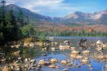
(Photo by John Burk)

