
You are here
65 year-old Fingerprints from 1938 Hurricane found in Remotely-Sensed Data
Analyzing airborne LiDAR (i.e., laser remote sensing) data acquired by NASA in 2003, researchers found differences in measures of 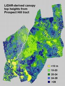 canopy structure in stands across the Prospect Hill tract at Harvard Forest. Canopy height and vertical diversity were related to the predominant species present and the intensity of wind disturbance from the 1938 hurricane and associated timber extraction efforts. Given the importance of canopy structure to habitat and ecosystem functions, such as gas exchange, this disturbance legacy probably continues to influence the ecology of impacted New England forests.
Weishampel, J.F., J. B. Drake, A. Cooper, J. B. Blair, M. Hofton. Forest canopy recovery from the 1938 hurricane and subsequent salvage damage measured with airborne LiDAR. 2007. Remote Sensing of Environment 109. pp. 142–153.
