History’s Insights into Martha’s Vineyard Today and Tomorrow: The 1850 Map by Henry Laurens Whiting
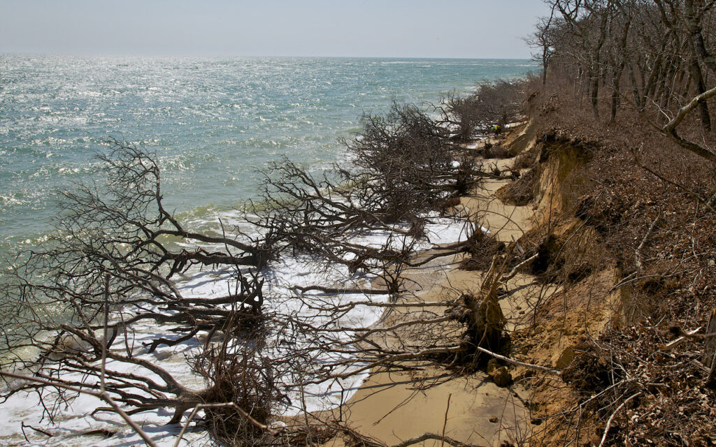
How do we interpret the New England landscape? What clues help explain the features we encounter—an abandoned cellar hole along a deeply eroded woods road, a derelict dam on a pristine stream, or an ancient chimney perched along the coast? As we look closer the natural variation mounts. Here we encounter towering pines, there immense and wide-spreading oaks, and elsewhere the bluffs support heathland and grass.
To interpret these patterns, we can apply our best science. But, we must not overlook one critical key to New England’s landscape—its history. To interpret the land today we need to understand how people, farm animals, and nature shaped it decades or centuries ago.
History is key because New England has a tumultuous past. By 1850 the region’s original forests were transformed into a landscape of villages and farms with expansive pastures and croplands. Remaining woods were scattered and heavily cut. Farmers and thousands of cattle and sheep kept the land open.
This agrarian scene was disrupted by forces in and beyond the region— westward expansion, railroads that brought inexpensive crops east, and the damming of New England rivers to power an Industrial Revolution that drew rural folk and immigrants to expanding towns. As agriculture declined forests reclaimed most of the land.;
We are a century and a half into New England’s globally important story of environmental recovery. Today, our woods continue to age, but as our landscape changes it is shaped as much by its history as by the weather or our actions today. On every coastline, along every stream and pond, and in every forest and field legacies of the past persist.
Developing the Map of Vineyard Lands and Waters
To develop this new version of Whiting’s map we extracted the Vineyard from a larger U.S. Coastal Survey chart—From Muskeget Channel to Buzzard’s Bay and Entrance to Vineyard Sound. The lands were surveyed by Whiting’s crew from 1844 to 1852 and surrounding waters from 1845 to 1857. A worn original of the beautifully engraved chart is archived in the Martha’s Vineyard Museum but for a year we searched fruitlessly for a pristine chart to scan. A chance visit to naturalist Nancy Weaver and mariner Dave Dandridge revealed a near flawless original hanging in their home on Lagoon Pond.
The map was scanned at Harvard’s Widener Library at a resolution of 1000 dots per inch and enlarged to display the fine detail. We inserted original elements from the larger chart: attribution to Superintendent Bache; distance scale; notes on survey dates, buoys, coastal dangers, and abbreviations; No Man’s Land; a locational inset map; and views of West Chop Lighthouse and Entrance to Vineyard Sound. We also added Whiting’s signature from his surveyor’s log and a legend.
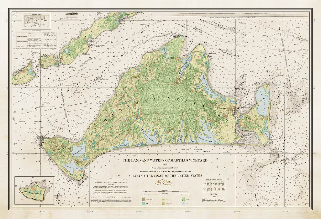
Careful study reveals the map’s stunning detail: bathymetry in feet where shallow and fathoms elsewhere; the composition of the sea-bottom (mud, sand, etc.); the speed of tidal currents; and major shoals. These details were surveyed in whaleboats by a crew of six oarsmen, a coxswain, two recorders, and an officer.
Inland features were mapped to aid navigation. The greatest ecological treasures are features seldom recorded on other maps: fence lines (stone walls and wooden rails), land cover (forests, swamps, fresh and saltwater marshes), and farms (pastures, cropland, hay fields, orchards, and cranberry bogs).
An Invaluable Resource for Evaluating Coastal Change
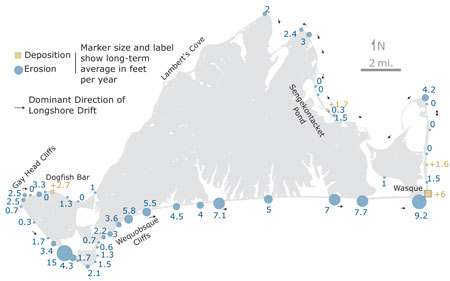
Determining erosion rates is critical for planning in the face of climate change. Repeat measurements by Whiting allowed him to publish the first good maps of erosion in the 1880s. Since then the Vineyard’s south shore and coastal ponds have changed remarkably.
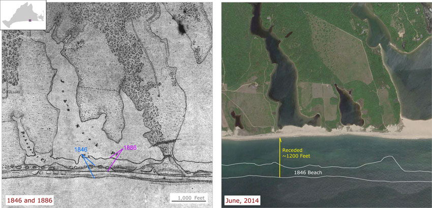
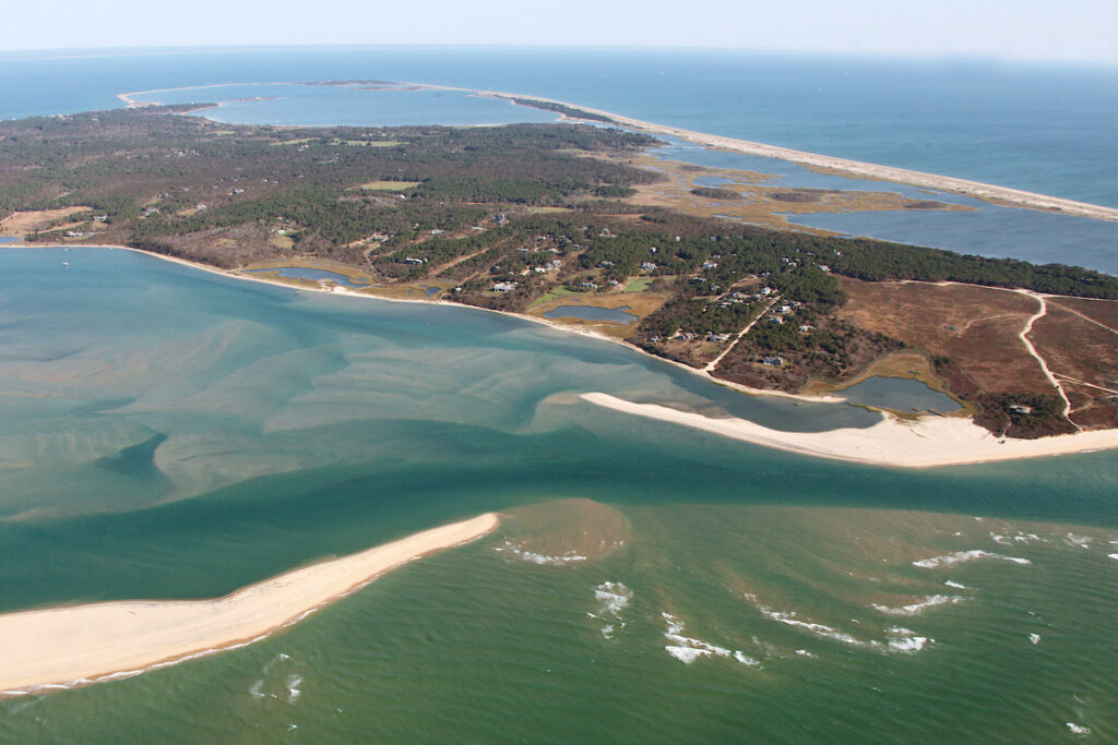
The breach of Norton Point severing the tenuous connection between Chappaquiddick and the Vineyard was repeatedly mapped and interpreted by Whiting.
Clifford Kaye of the U.S. Geological Survey used Whiting’s map to assess the variable rates of erosion around the Vineyard.
Identifying Critical Forest for Conservation
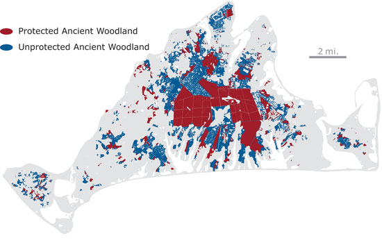
The persistence of vast ancient woodlands was not perceived or valued in early land planning and so many large woodlands documented by Whiting have been destroyed, fragmented, or perforated by housing.

While the total area of forest cover has increased by fifty percent in the past 150 years, ancient woodland has declined by thirty percent.
When Henry Whiting was mapping the Vineyard the landscape was substantially open and more extensively influenced by humans, sheep, and cows than at any other time.
The 1850 map allows us to document that condition and the recovery of forests. We can then distinguish ancient woodlands – areas never cleared but used as woodlots – from secondary woodlands that developed on former farmland.
This helps explain the modern variation across the island today and prioritizes ancient woods for conservation.
A Landscape Transformed
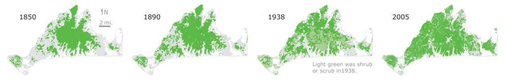
In 1850 the Vineyard was predominantly cleared agricultural land (gray) with the large woodland on the Great Plain heavily cut and occasionally burned. Following 150 years of farm abandonment maturing forests now cover much of the landscape. Every part of the island displays the consequences of centuries of land use.
Guides to the Nineteenth Century
Where do we turn to decipher this history so that we can interpret our landscape and anticipate its future? We read much in the shape of trees, the patterns of ancient ways, and the remains of buildings and piers. We can turn to diaries, census records, and newspapers for details. But maps provide the best guide to landscape history.
For 19th century New England the best maps come from an obscure agency—the U.S. Coastal Survey. And the most comprehensive of these captures Martha’s Vineyard around 1850 at its zenith of agrarian activity. In a fluke of history, the young man in charge of the survey crew that began its work in Edgartown in 1844 fell in love with the Island, and made it the center of his life. The map resulting from Henry Whiting’s efforts provides an unrivaled view into his world and ours.
“Henry Whiting could make a better map without seeing it than others could while standing before it.”
– Science Magazine 1897
The U.S. Coastal Survey
The map’s origins lie in legislation advanced by President Thomas Jefferson in 1807 establishing a coastal survey to: (i) assist navigation, (ii) develop harbors, and (iii) guide military defense. Ferdinand Hassler, a Swiss mathematician and engineer with a reputation for perfection headed the Survey until 1843. Hassler spent much of his time scouring Europe for the finest surveying and engraving equipment, battling Congress for funds, and recruiting elite military officers to infuse the survey with talent and discipline.
His successor, Alexander Dallas Bache, great-grandson of Benjamin Franklin and co-founder of the National Academy of Science, was a man of action and science. By 1860 the Survey had mapped more than 25,000 lineal miles of shoreline.
Whiting led a typical survey crew on the Vineyard: four to six men living in tents who employed triangulation to tie their local measurements into a regional baseline. Portions of Whiting’s log and the journal of Samuel Gilbert, who went on to be a Brigadier General, are archived in the Martha’s Vineyard Museum. Meanwhile, NOAA retains many original field records, draft maps, and charts.
Praise for the 1850 Map
Whiting’s original survey produced a series of defining maps. The accuracy and detail of this work was lauded by the Vineyard Gazette in 1848 when the first charts appeared.
“Were our people aware of the manner in which these charts are engraved and published, there is not a family in town but would procure one as soon as possible. What surprizes us most is, that the roads running to and on the island, are laid down so correctly… A correct description of every pond, with its outlet, or path leading thereto…besides a scale of miles, by which anyone can ascertain the exact distance (within a foot or less) from one point to another. But this is not all. To the mariner, passing in and out of our harbor… this chart contains information of incalculable importance. The outlines of the coast, the position of the light houses, buoys and rocks, with shoals and soundings, are… perfect, or as near perfection, as science, at the present day will admit. It is, in fact, beyond improvement… Perhaps some will ridicule the idea of placing one of them in their parlor… they are an ornament to the room of any gentleman.”
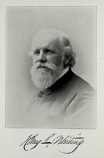
Henry Laurens Whiting, a descendent of Governor William Bradford, was hired in 1838 and served as the Survey’s chief cartographer until his death in 1897. He settled on a small farm in West Tisbury and, despite endless travels, immersed in farm and Vineyard life. Notably, he joined with Leavitt Thaxter in 1856 to found the Martha’s Vineyard Agricultural Society.
Whiting’s Island legacies are diverse. His son Johnson was an early owner in Seven Gates Farm where Whiting Hill supports one of the Vineyard’s oldest and most diverse woods. Many Whiting relations shaped the Vineyard landscape: Probate Judge Everett Davis whose real estate dealings spanned Chilmark and West Tisbury; the Newhalls who gifted Agricultural Society lands; and the Woods whose 500+ acre Nature Conservancy preserve links the Polly Hill Arboretum, the Agricultural Society, Waskosim’s Rock, and Seven Gates Farm into the Island’s largest block of conserved morainal forest. Today, the Whiting name distinguishes farmers, artists, naturalists, and town officials.
Through his life Henry Whiting repeatedly resurveyed the Island. One result: a definitive interpretation of coastal erosion and breach formation at Norton Point.
Field notes from the 1846 survey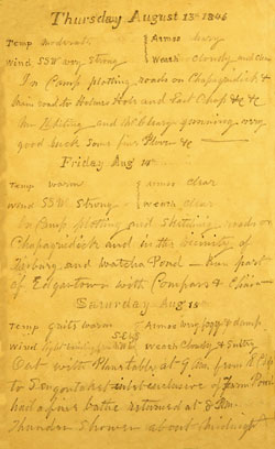
One young member of Whiting’s crew kept a daily journal. On August 13, 1846 Samuel Gilbert wrote “In Camp plotting roads on Chapaquidick & main road to Holmes Hole and East Chop etc. etc. Mr. Whiting and McClary gunning – very good luck some five Plover etc.”
Related Publications
- Wildlands and Woodlands: A Vision for the New England Landscape.
David Foster and others. 2010. Harvard University Press. - Thoreau’s Country: Journey Through a Transformed Landscape.
David Foster. 1999. Harvard University Press. - Historical Influences on the Landscape of Martha’s Vineyard. Perspectives on the Management of the Manuel Correllus State Forest.
David Foster and Glenn Motzkin. 1999. Harvard Forest Paper 23.