
You are here
GIS & Maps
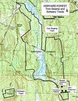
Historic GIS data for Harvard Forest Properties 1908 - Present
Since 1908, the Harvard Forest has conducted forest surveys approximately every 10-20 years on its three largest tracts (total 1033 ha). These maps have been digitized along with maps of environmental factors (topography, soils), disturbance (1938 hurricane, historical land-use), and silvicultural treatments. These datalayers will allow researchers to understand the influence of environment factors, disturbances, and silviculture on the structure and composition of modern forest stands as well as assisting in locating and describing research sites. The dataset also includes an elevation grid (NED 30 meter cells), and a shapefile of linear features (trails, stonewalls, etc).
Original maps were transcribed to standardized basemaps by various researchers. These basemaps were then scanned and digitized as shapefiles in ArcView GIS 3.2. The shapefiles were then transformed to Massachusetts State Plane Meters NAD83 projection in ArcGIS and rubbersheeted to align better with aerial photographs downloaded from MassGIS. Locations of control points will be permanently archived at the Harvard Forest to facilitate transformation of future datalayers.
Download GIS Layers of tract boundaries and linear features only. (including: roads, trails, stonewalls, etc.).
Harvard Forest Data Map
The Harvard Forest Data Map (HFDM) incorporates the technology of Geographic Information Systems (GIS) with the research conducted at specific locations. With the support of the Harvard University Provost's Technology Grant and the Center for Geographic Analysis, we have combined extensive GIS spatial records for the Harvard Forest with the research data collected at those sites. The HFDM allows users to choose an area of interest on the map (by spatial or physical descriptions) and get a series of links (via URLs) to all of the environmental, historical, and research data electronically available for that area. View the map.
Maps available in Archive
Harvard Forest has a large collection of maps, including research-created maps, USGS maps, and historical maps of Massachusetts. A catalog of maps can be accessed on-site.
