
You are here
Interactive Map Highlights History and Ecology of Martha's Vineyard
New, deeply researched maps of Martha's Vineyard encourage exploration of the Island by first invoking the Island's past--how people, nature, and farm animals shaped it centuries ago.
The maps are a precursor to the forthcoming book, A Meeting of Land and Sea: Nature and the Future of Martha's Vineyard, written by Harvard Forest Director David Foster following 20 years of research on the Island. The book, written for a broad audience and bedecked with rich photos, illustrations, and maps, will be published in January 2017 by Yale University Press.
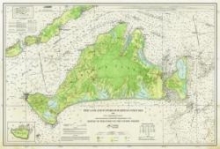
An interactive map viewer, created by Harvard Forest GIS Research Assistant Brian Hall, allows online viewers to toggle between the modern day landscape and 19th-century farms, woodlots, orchards, bogs, and rails at the Island's agricultural peak. An exqusitely detailed 19th-century survey chart by Henry Laurens Whiting forms the historical framework for the interactive map. Whiting's map, newly updated by a Harvard Forest design team (Foster with Jenny Hobson), is now also available in printed form, with proceeds to benefit the development of a modern flora for Martha’s Vineyard and research in plant conservation and forest ecology at Polly Hill Arboretum.
Foster presented the map and its history to a packed crowd in West Tisbury on July 7.
