
You are here
Projects
Projects
Forest Landscape ModelingFunding sources: LTER, the Highstead Foundation, DISES The potential and uncertainty associated with New England forests’ ability to continue providing ecosystem services is critical to understand. The Thompson Lab has been using the forest landscape model LANDIS-II for a variety of projects. Using scenarios to drive experimental simulation design, we explore the effects of land use, climate change, and other disturbances on forest landscapes. We project the fate of aboveground carbon, forest species composition, and forest productivity following the interaction of various global change drivers (e.g., climate change, invasive pests, and land use change). |
Liang, Y., Gustafson, E. J., He, H. S., Serra-Diaz, J. M., Duveneck, M. J., Thompson, J. R. 2022. What is the role of disturbance in catalyzing spatial shifts in forest composition and tree species biomass under climate change?. Global Change Biology 10.1111/gcb.16517: 18 pp. |
How might natural and working lands (NWL) affect C stocks and GHG emissions in Massachusetts?Funding Source: Commonwealth of MA, Executive Office of Energy & Environmental Affairs Massachusetts’ forests currently store an estimated 111 Tg of live carbon (C) and serve as a C sink, sequestering more C than they release. However, changing climate has the potential to increase the risk of natural disturbances and the spread of invasive insect pests. The Thompson and QuantEEL (Quantitative Ecology and Environmental Literacy -Meg Graham MacLean- UMass) Labs are conducting an analysis for the Commonwealth of MA to quantify these risks to carbon stocks by implementing a set of possible future scenarios that bracket a range of possible risk trajectories and changes in land use type under a high-emission climate scenario. The QuantEEL lab will track the harvested wood products using a model that they developed to calculate emissions and stocks of harvested and hurricane-damaged wood pools. |
Map showing areas that will be affected by EF (enhanced Fujita) 2 or greater hurricanes in the simulations. Color indicates the earliest year affected. Gray indicates no EF 2 damage in the simulations. |
Does land conservation raise property taxes? Evidence from New England cities and townsFunding Source: USDA NIFA (Agricultural and Food Research Initiative, Environmental and Natural Resource Economics Priority Area, Grant #2021-67023-34491) Opposition to new land protection in the U.S. is frequently driven by the perception that it erodes local property tax bases, leading to increased tax burdens on other landowners and/or reduced revenue available for local public goods. Proponents of land protection counter by arguing that open space pays for itself because it requires fewer municipal expenditures than developed land, or because it creates recreation-based economic opportunities and amenity values that increase the property tax base. Despite the crucial role that local property taxes play in funding public goods, few studies have quantified the possible impacts of land protection on property tax rates to inform this debate. To fill the void, we are characterizing the impacts of land protection on property tax rates and other fiscal outcomes for more than 1400 municipalities in New England from 1990-2015. |
Kalinin, A. V., Sims, K. R. E., Meyer, S. R., Thompson, J. R. 2023. Does land conservation raise property taxes? Evidence from New England cities and towns. Journal of Environmental Economics and Management 10.1016/j.jeem.2022.102782: 102782. |
Solar Siting in MassachusettsFunding Source: Massachusetts Aububon Society Decarbonizing the electricity grid and maintaining healthy forest ecosystems are essential strategies for creating a more sustainable future under climatic change. In Massachusetts, one of the most densely populated and forested states in the US, these two necessities are conflicted due to policies that incentivize solar development in forests and other natural or working lands whose value extends far beyond carbon. As the Commonwealth strives to achieve its legislatively-mandated clean energy goals, where to site solar arrays, and what policies can support a just and equitable distribution of solar development, are urgent questions. We are working with conservation and policy experts at Mass Audubon to research the extent to which the Commonwealth can meet its clean energy goals without siting solar on forestland or other land with environmental or cultural values. More broadly, we aim to study solar development in Massachusetts as a relatively new and rapidly expanding forest disturbance that impacts forest ecosystems, land protection, and the Commonwealth’s overall land use regime. |  |
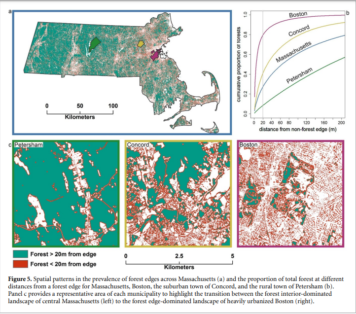
Forest Edge Effects
Forest fragmentation, a direct consequence of land-use change, is pervasive throughout the world’s forests. Fragmentation creates a matrix of many, smaller patches of non-contiguous forest and the proliferation of forest edges. In temperate forests, over 17.5% of forest area is within 30 meters of a forest edge. Edge forests are affected by lateral exposure to sun, wind, and human activity on the adjacent non-forest land use. These perturbations to the fundamental constraints on forest ecosystems, or edge effects, alter forest dynamics and carbon cycling relative to the forest interior. We are working with collaborators at Boston University and Hunter College to understand how temperate forest edges in the northeastern US differ from their interior counterparts. We use observational field data, remote sensing, and forest inventories to understand the implications of edge effects for forest ecosystems across multiple scales. |
Reinmann, A. B., I. A. Smith, J. R. Thompson, and L. R. Hutyra. 2020. Urbanization and fragmentation mediate temperate forest carbon cycle response to climate. Enivronmental Research Letters 15. https://doi.org/10.1088/1748-9326/abbf16 |
Forest Landscape EcologyFunding Source: NSF 20-579 Dynamics of Integrated Socio-Environmental Systems (DISES)
This project looks to understand how timberland financialization in the US has affected harvest, carbon, and human community dynamics, and examine the social and environmental feedbacks of the commercial timberland system. The research builds upon advances in land detection technologies via the application of the LandTrendr tool to landscapes that have undergone ownership transitions and upon scenario modeling tools developed at Harvard Forest. |
|


Past projects
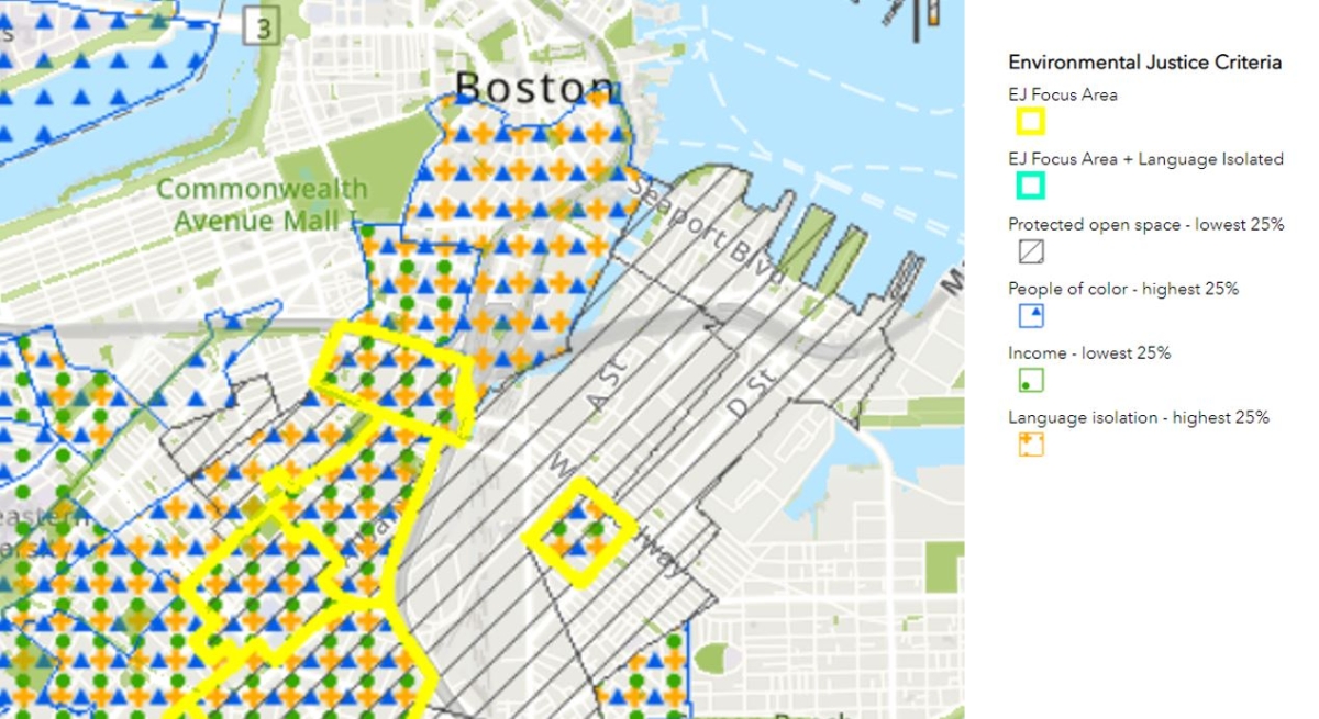
Land Conservation and Environmental JusticeAs human beings, access to nature is essential for our wellbeing. Land protection is one mechanism of creating and sustaining access to nature in societies, like that of the United States, where day-to-day life for most people is separated from nature by processes of urbanization and industrialization. In the United States, we collectively spend millions of public tax dollars each year on land conservation, yet the benefits of land conservation are not equally available to all members of the public. Disparities in access to the benefits of nature result from multiple forces, including systems of oppression operating in society and the motivations and information used to prioritize land for protection. Traditionally, the mainstream land protection community has relied on data about non-human animals, plants, bedrock geology, soils, or the like to inform land conservation, with less focus on human conditions or needs. Our research aims to understand how approaching land protection through an environmental justice lens, thereby putting more emphasis on human concerns, could affect patterns of future land protection in New England, and the potential of land protection to improve equity in access to nature across the region. |
The interactive Incorportating Environmental Justice Criteria in Land Conservation mapping tool identifies areas with a high degree of social marginalization and low amount of protected open space. |
Deforestation Scenarios in Central PanamaWorking in central Panama, we coupled a 1-ha resolution LiDAR derived carbon map with a locally derived secondary forest carbon accumulation model. We used Dinamica EGO 4.0.5 to spatially simulate forest loss across the landscape based on recent deforestation rates. We used local studies of belowground, woody debris, and liana carbon to estimate ecosystem scale carbon fluxes. Accounting for 58.6 percent of the forest in 2020, secondary forests (< 50 years) accrue 88.9 percent of carbon in the GO scenario by 2050. RT and AD scenarios lost 36,707 and 177,035 ha of forest respectively by 2030, a carbon gain of 7.7 million Mg C (RT) and loss of 2.9 million Mg C (AD). Growing forest on all available land (GE) could achieve 56 percent of Panama’s land-based carbon sequestration goal by 2050. Our estimates of potential carbon storage demonstrate the important contribution of secondary forests to land-based carbon sequestration in central Panama. Protecting these forests will contribute significantly to meeting Panama’s climate change mitigation goals and enhance water security. |  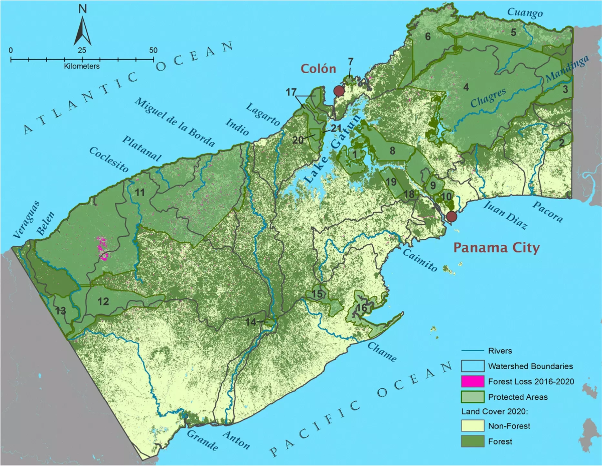 |
STEM Teaching Tool Highlights Urban Watershed DataScience teacher Tara Goodhue of Greater Lowell Technical School worked throughout summer 2020 with Josh Plisinski of the Thompson Lab to learn geospatial mapping techniques and analyze ecosystem services data from the public watershed that serves her school. The work was funded by a Research Experience for Teachers grant from the National Science Foundation as part of the Forest's Long-Term Ecological Research (LTER) Program. |  |
Assessing the Potential for Climate Change and Forest Insects to Drive Land-use Regime Shifts |  |
New England Landscape FuturesAnticipating landscape- to regional-scale impacts of land use on ecosystems and the services they provide is a central challenge for scientists, policy makers, and resource managers. By engaging with stakeholders to analyze plausible land use scenarios, scientists can bypass the inherent uncertainties associated with prediction within socio-ecological systems. Engaging with stakeholders also serves to maximize the legitimacy, salience, and uptake of the results. The Harvard Forest Future Scenarios Project integrates these elements into a participatory research initiative that develops, simulates, and analyzes land use scenarios. Using consistent assumptions about major drivers and constraints, the stakeholder-defined scenarios describe futures that include different amounts, intensities, and spatial configurations of land development, timber harvesting, farmland expansion, and forest conservation. All scenarios include the assumption that average temperature and precipitation will increase with climate change, Scenarios are simulated using the spatially interactive, process-based forest landscape model, LANDIS-II and evaluated in terms of their impacts on direct human uses of the landscape (developed land, agriculture, timber harvest), ecosystem services (carbon storage, flood regulation, nutrient retention), and biodiversity conservation (forest composition, interior forest habitat). |  |
Climate change and wildfire interactionsThe frequency and severity of wildfires is increasing throughout much of the West. Moreover, the process of ecosystem recovery after wildfires is changing, especially where droughty conditions slow tree seedling establishment and growth. Scientists are concerned that these changes will force ecosystems over critical thresholds – so called tipping points – wherein the dominant vegetation permanently shifts from forests to shrubs. The 25-million acre (10 million hectare) Klamath region of Oregon and California is an area of particular concern. Such a shift in the Klamath would impair its unparalleled botanical diversity (e.g. there are 29 species of conifer trees in the Klamath!) and release massive amounts of greenhouse gasses as some of the most carbon dense forests in North America transition to low-carbon shrub-chaparral. The scientists working on this project will evaluate the potential for a critical transition in the Klamath and collaborate directly with the U.S. Forest Service to identify robust strategies for ecosystem management in the face of climate change. Including the participation of Forest Service decision-makers, who manage 80% of the Klamath region, will ensure the transparency and credibility of the science, thereby increasing its impact on environmental outcomes. | |
Scenarios, Services, and Society (S3) Research Coordination NetworkThe main objectives of the Scenarios, Services, and Society (S3) RCN are to synthesize existing science, catalyze new research, and produce science products to understand and advance sustainable land-use trajectories. The major activities of the S3 RCN are to:
|
.
